


eparges 3

ochelen
User
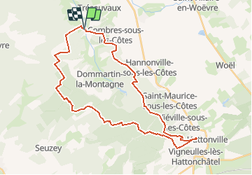

Length
36 km

Max alt
411 m

Uphill gradient
735 m
Km-Effort
45 km

Min alt
263 m

Downhill gradient
736 m
Boucle
Yes
Creation date :
2014-12-10 00:00:00.0
Updated on :
2014-12-10 00:00:00.0
5h35
Difficulty : Unknown

FREE GPS app for hiking
 SityTrail
IGN / Geographical institutes
SityTrail Plus
The world is yours!
About
Trail Equestrian of 36 km to be discovered at Grand Est, Meuse, Les Éparges. This trail is proposed by ochelen.
Description
eparges hattonchatel eparges
Positioning
Country:
France
Region :
Grand Est
Department/Province :
Meuse
Municipality :
Les Éparges
Location:
Unknown
Start:(Dec)
Start:(UTM)
689521 ; 5437738 (31U) N.
Comments